Drone

Putin's Special Aircraft Nearly Attacked by Drone, Unveiling the New Missions and Challenges of Offense and Defense in Modern Warfare
The incident of President Putin’s aircraft being attacked has sparked widespread concern over the threat of drones. The article analyzes the security challenges posed by drones in both military and civilian fields, introduces countermeasure technologies such as low-altitude security radars and their multi-scenario applications, and emphasizes the importance of balancing technological innovation with security control.
Read more
Photoelectric Detection and Acoustic Anti-Drone Systems: Core Technical Differences and Application Scenarios Comparison
The advancement of drone technology has brought conveniences to both military and civilian applications, but it has also introduced significant security threats. Globally, efforts are actively underway to develop counter-drone systems. Through technologies such as electro-optical and acoustic detection, these systems enable precise identification, tracking, and neutralization of drone threats to address emerging challenges.
Read more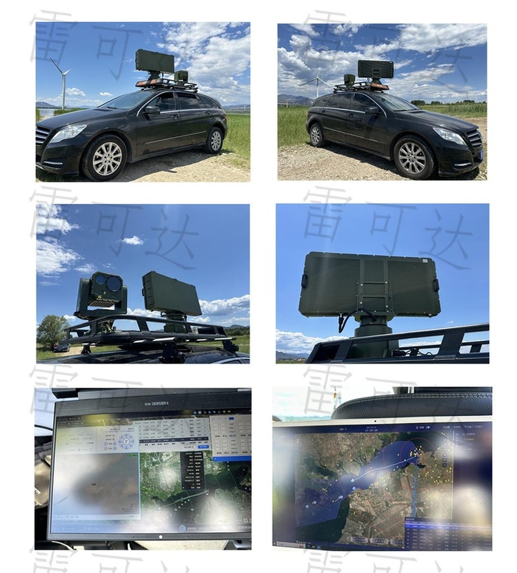
Lakeda Product Testing Site Attracts Industry Attention, Multiple Companies Vie to Observe!
Wuhan Lakeda successfully held a concentrated radar product testing week from July 1 to 5, attracting numerous enterprise representatives to observe on-site. The event involved systematic testing of multiple low-altitude security and border/coastal defense radar systems, effectively validating product performance and enhancing the company’s industry influence and collaboration opportunities.
Read more
Drone Radar Mapping System: Comprehensive Analysis of Application Fields and Industry Guide
This article systematically analyzes drone LiDAR (Light Detection and Ranging) technology, detailing its principles of generating high-precision 3D models through laser mapping. It also highlights its innovative applications across eight major fields, including agriculture, mining, power inspection, and archaeology, demonstrating its value in efficient surveying and digital transformation.
Read moreDrone Radar Technology: A Comprehensive Analysis of Industry Application Scenarios and Innovative Solutions
The integration of drone-mounted radar technology brings three major innovative applications: breaking through low-altitude detection limitations, enabling flexible radar testing and validation, and establishing a collaborative communication relay platform. This significantly expands the detection range and enhances system performance, offering new solutions for the radar industry.
Read more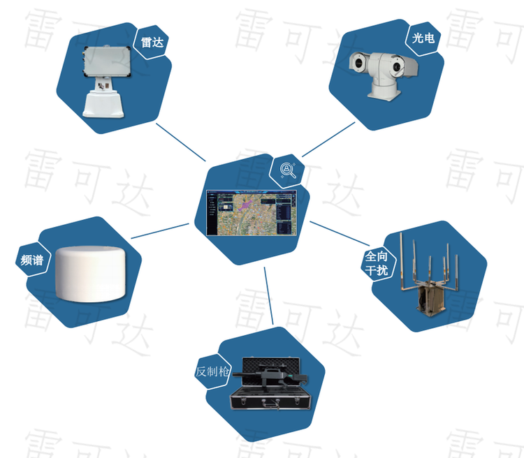
Drone Countermeasure System: Efficient Low-Altitude Defense Solutions and Application Guide
In response to the security risks brought by the widespread use of drones, our company has independently developed a “Low-Altitude Defense System.” Integrating detection, tracking, and jamming capabilities, it can precisely counter “low, slow, and small” drones, effectively ensuring regional security.
Read moreHow Effective is Drone Radar Mapping? An Analysis of the Five Major Advantages of Real-Scene Modeling
The drone detection radar system (LiDAR) accurately acquires three-dimensional surface information by emitting and receiving laser pulses. Unaffected by weather conditions, this technology can penetrate vegetation and efficiently generate high-precision terrain data, making it widely applicable in fields such as mapping, exploration, and geographic information.
Read more